Why Old Field Boundaries Rarely Run Straight
Why old field boundaries rarely run straight: learn to read bends, jogs, and curves as clues to terrain, water, and changing use without assuming one origin.
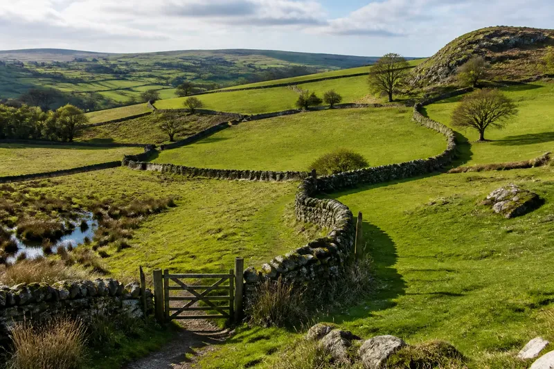
On a map, one field edge bends around a damp hollow, then jogs toward a gate before wandering beside a low ridge. That uneven line is often the clue: old field boundaries rarely run straight because people fitted their working ground to land that was already varied and to uses that changed over time.
A crooked boundary is not a code with one translation. Its shape may reflect slope, drainage, access, earlier cultivation, or several influences layered together. Reading it well means noticing what the line does, then asking which explanations fit the ground.
What does a boundary line actually record?
A boundary marks a division, but it can also preserve traces of how land was made workable. A line on a modern map may follow an old bank, a shallow ditch, a stream, or a track. Elsewhere, it may simply connect practical points: a gate, a field corner, a dry patch, or the edge of ground that was difficult to plow.
Think of the line like a seam in a well-used coat. It records where pieces were joined, but not necessarily who stitched them or why. The shape is evidence of a division; it does not, by itself, reveal the date or the decision behind it.
That distinction matters because familiar explanations can sound more certain than the landscape allows. A boundary that curves around a hill might have been set to suit the slope, but the curve could also preserve an older enclosure or avoid a wet spot that is no longer obvious. Begin with visible relationships rather than a story.
How can terrain bend a field edge?
Sloping ground makes straight lines less convenient. A boundary may follow a contour, keeping to broadly similar levels rather than climbing directly uphill. That can leave a long, gentle curve. On steeper ground, a line may zigzag between usable patches or turn around a rocky outcrop that made cultivation awkward.
Look for the relationship between the boundary and the shape of the land. Does the line track along a ridge, skirt a hollow, or cross a slope at an angle? A contour-following edge may have helped keep work manageable, but it could also mark a natural division that people adopted later. The landform supports a possibility; it does not settle the question.
Small changes in relief can matter too. A slight rise may provide firmer footing beside a wet hollow, while a low shoulder may separate ground with different drainage. On a paper map those details can be subtle. A topographic map, aerial image, and careful look from a public path can help you see whether the boundary’s bends correspond to them.
What can water explain?
Water leaves especially suggestive patterns. A field edge may follow a stream, a drainage channel, or the margin of ground that stays wet. It may also take a crooked route around a spring or a patch that floods after heavy rain. A ditch can appear to lead the boundary, or the boundary can run alongside a ditch that was added later.
Check whether the line connects wet features or simply skirts one isolated patch. Look for a visible channel, a change in vegetation, or a low strip that carries water downhill. These clues can help distinguish a boundary shaped by drainage from one whose bends happen to cross damp ground.
Water routes shift, and drainage works can change them. A mapped stream may no longer follow its earlier course, while a ditch may make a former wet edge look like a deliberate engineering line. Treat present-day water as a clue to the land’s behavior, not an exact record of what the boundary’s first makers saw.
How did ordinary use leave irregular lines?
Fields were not always divided in one clean operation. A boundary could grow as people extended cultivation, enclosed a useful patch, or joined existing parcels. One edge might follow a track; another might meet an older enclosure at an awkward angle. The resulting outline can look untidy because it preserves separate decisions rather than a single design.
Access often explains the small jogs. A boundary may bend to keep a gate reachable from a lane, leave room for turning animals or equipment, or connect with a route between fields. A narrow projection could mark access to water or a strip of ground used differently from the rest. Such details are worth noticing, but they are not proof of a particular custom.
Imagine a farmer working a sloping parcel with a soggy corner and an established track along one side. In an invented situation, the farmer keeps the boundary near the track, curves it around the wet patch, and makes a short turn where a gate can serve both adjoining fields. The resulting edge would be irregular, and its visible bends would fit several practical needs without pointing to just one cause.
Which clues help tell possible origins apart?
Read the boundary in context. Compare its curve with the slope, watercourses, neighboring edges, tracks, and signs of older land divisions. A bend that follows a ridge for a long distance suggests a different relationship to the ground than a short notch beside a gate. Neither shape names its origin, but comparison narrows the plausible explanations.
- Follow the line: Is it one smooth curve, a series of short turns, or a straight run interrupted by a jog? Note the pattern before assigning a cause.
- Compare the relief: Does it track a contour, cross a steep slope, or wrap around a rise? This may suggest how terrain influenced the division.
- Look for water: Check for a stream, ditch, wet hollow, or low strip nearby. Ask whether the boundary follows it or merely approaches it.
- Notice connections: Where does the line meet a track, gate, or neighboring boundary? A useful junction may help explain a local turn.
- Compare nearby parcels: Repeated bends or matching angles can suggest that several divisions relate to one another, though they may still reflect different periods of use.
- Keep alternatives open: Write down more than one explanation when terrain and access both fit. A map shape alone rarely rules out either.
For a specific place, old maps and local records may add context, but their labels and dates need careful interpretation. Access to land and archives varies, and local rules govern where visitors may walk; stay on permitted routes.
What questions should you ask before naming a boundary?
Does a curved line mean the field followed a contour?
It can, especially if the edge stays at a similar height along a slope. But a curved line may also reflect water, an older division, or a practical route, so compare it with the terrain and neighboring features.
Can a sharp jog show where a field was enlarged?
It may be consistent with a later adjustment or with two parcels meeting, but the jog alone cannot establish when or why it appeared. Look for related patterns in adjacent boundaries and any available maps.
Why do some edges look more irregular than others?
Some parcels combine ground with different slopes, drainage, or access, while others may have been laid out more uniformly. The contrast is a prompt to inspect the setting, not a reliable measure of age.
Can a modern map reveal the original boundary?
A modern map shows a present representation, which may preserve an old line or simplify it. Comparing map editions and visible landscape features can clarify what changed, but neither should be treated as a complete account on its own.
How should you describe what you see?
Use language that separates observation from interpretation. “The boundary curves around a hollow” describes what is visible. “The curve was made to avoid wet ground” is an explanation that needs support. Keeping those statements distinct makes your reading more useful, especially when the same line could fit several stories.
Old field boundaries rarely run straight because working land is rarely uniform, and because one division can carry traces of more than one choice. Follow the bends across the ground, check what they meet, and let the shape suggest questions before it supplies answers. A careful description may be more revealing than a confident origin story.